U.S. Soy and Cropland
- A peer-reviewed study published in the journal Land demonstrates a comparable amount of U.S. cropland moving in and out of production over a 35-year period[1]
- A second peer-reviewed study published in International Journal of Geo-Information demonstrates multiple data sets are required to accurately assess land use change[2]
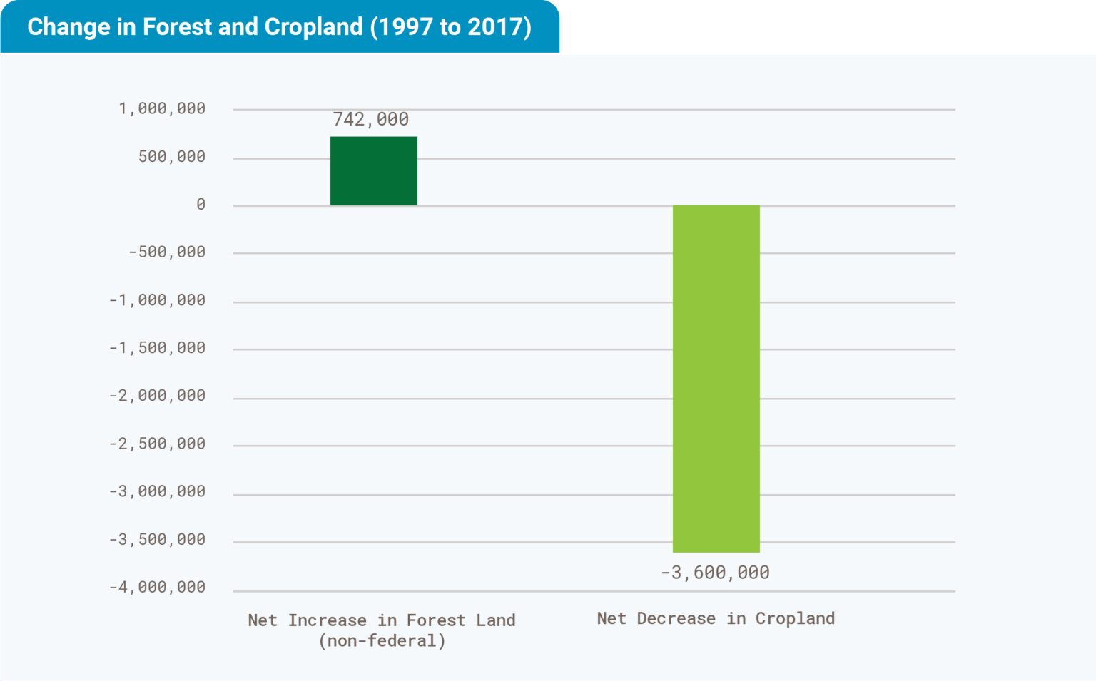
- U.S. forest land has increased 742,000 hectares while cropland decreased by 3.6 million hectares from 1997 – 2017[3]
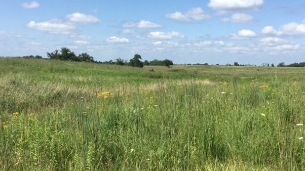
U.S. Soy farmers are passionate about their land and committed to preserving it for future generations. They understand the significance of maintaining its health to sustain crop growth that helps nourish people and the planet. They actively pursue innovative methods to maximize productivity while minimizing resource usage.
Government-supported conservation programs provide incentives for many farmers’ sustainability goals and plans. Some programs take farmland out of production for conservation programs, such as water quality protection, soil conservation and improvement, wildlife habitat expansion and grassland habitat renewal. Approximately 15% of U.S. farmland is currently set aside for conservation, forest development and wildlife habitat. In fact, forest land across the U.S. has increased by 742,000 hectares and cropland decreased by 3.6 million hectares from 1997 to 2017.
A peer-reviewed research study by Kenneth Copenhaver titled ‘Combining Tabular and Satellite-Based Datasets to Better Understand Cropland Change,’ published in the journal Land in 2022, examined previous studies that had analyzed satellite imagery. These studies suggested significant land conversion to crops in the U.S. However, Copenhaver’s study specifically noted that the satellite images used in those studies did not provide the necessary accuracy to substantiate their conclusions.
Copenhaver analyzed satellite datasets in addition to tabular datasets and aerial imagery to see if they could provide a more accurate picture of land use change. “Analyses of satellite imagery data from 1985 to 2020 found that much of the land that 2008 to 2020 satellite datasets classified as natural-to-cropland change was idle cropland,” Copenhaver wrote. “The results indicate a dynamic landscape of marginal land moving in and out of cropland. Approximately as much land was allowed to go fallow (6145 hectares) as land going into crop (7901 hectares) from 1985 to 2020.”
A separate 2021 peer-reviewed study published in the International Journal of Geo-Information explored the accuracy of Cropland Data Layer (CDL), used by the U.S. Department of Agriculture, in assessing crop production areas and changes to cropland use. Examining the Characteristics of the Cropland Data Layer in the Context of Estimating Land Cover Change, a study published by Kenneth Copenhaver, Yuki Hamada, Steffen Mueller and Jennifer B Dunn, showed that the estimated area of cropland changes from 2007 to 2012, 2008 to 2012 and 2012 to 2017, varied widely between the CDL and tabular data, with the CDL estimating a much larger change area.
The study said that image processing techniques that had been designed to improve the confidence in cropland change estimated using the CDL reduced the area of estimated cropland change. Estimated land cover change area varied widely based on analyses applied and could reverse from increasing to declining area in cropland.
“Further analyses showed unlikely change scenarios when comparing different year combinations.”
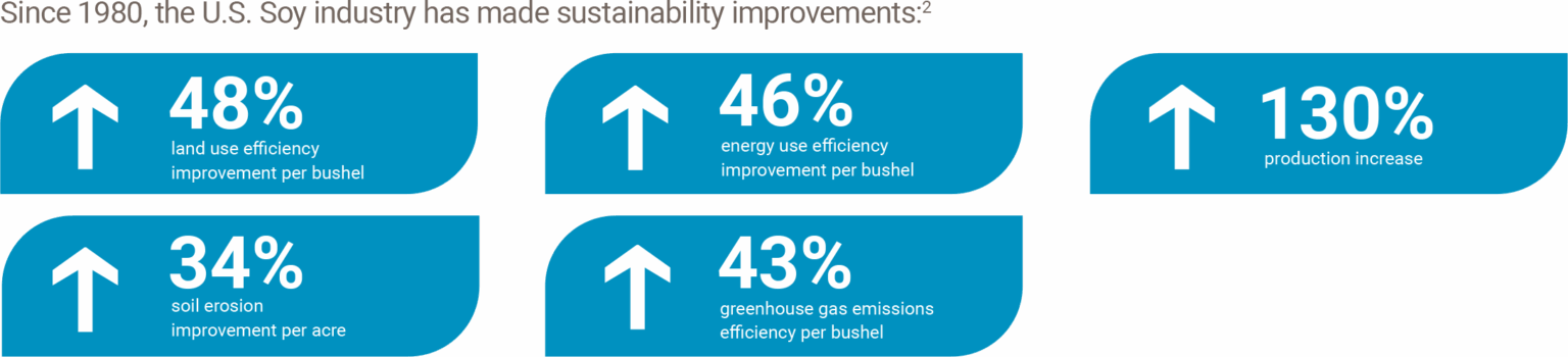
U.S. soybean farmers are constantly exploring opportunities to improve their existing land, rather than expand their landholdings. As the statistics in the graphic above show, farmers have successfully achieved greater efficiency across land use change and greenhouse gas emissions, mitigated soil erosion, and boosted soy production.
These same U.S. soybean farmers also have a low carbon footprint. When land use change is considered, such as deforestation to develop more cropland, the U.S. comes in well below other countries.
U.S. farmers are focused on continuous improvement—consulting advisers, university research, industry publications and other resources to learn how to be more productive while mitigating the impact of their local footprint, on their region’s natural resources, and on the global environment. Each decision and each action that a U.S. soybean farmer takes provides an opportunity to actively pursue sustainable production.
U.S. Soy farmers are also leading the way in implementing conservation tillage and sustainable precision and regenerative agriculture practices. This includes minimizing soil disturbance, maximizing crop diversity, ensuring the soil remains covered with crop residue or growing plants, maintaining living roots in the soil, and integrating livestock. These approaches are part of a broader commitment by U.S. Soy farmers to sustainability. That commitment ensures they not only continue to produce food, feed and energy to support a healthy society, but also preserves the planet for future generations.
This story was partially funded by U.S. Soy farmers, their checkoff and the soy value chain.
[1] Copenhaver, K. L. (2022). Combining Tabular and Satellite-Based Datasets to Better Understand Cropland Change. Land, 11(5), 714. MDPI AG. Retrieved from http://dx.doi.org/10.3390/land11050714
[2] Copenhaver, K., Hamada, Y., Mueller, S., & Dunn, J. B. (2021). Examining the Characteristics of the Cropland Data Layer in the Context of Estimating Land Cover Change. ISPRS International Journal of Geo-Information, 10(5), 281. MDPI AG. Retrieved from http://dx.doi.org/10.3390/ijgi10050281
[3] U.S. Department of Agriculture’s Natural Resources Conservation Service. (2017). National Resources Inventory (NRI). Natural Resources Conservation Service. https://www.nrcs.usda.gov/nri